Category Archives: Weather

Oregon Inlet

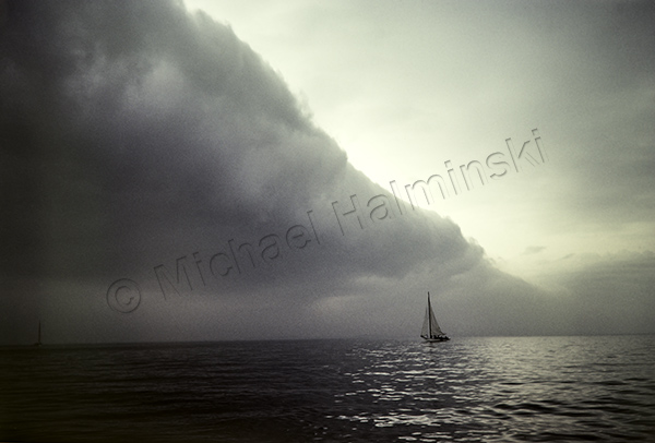
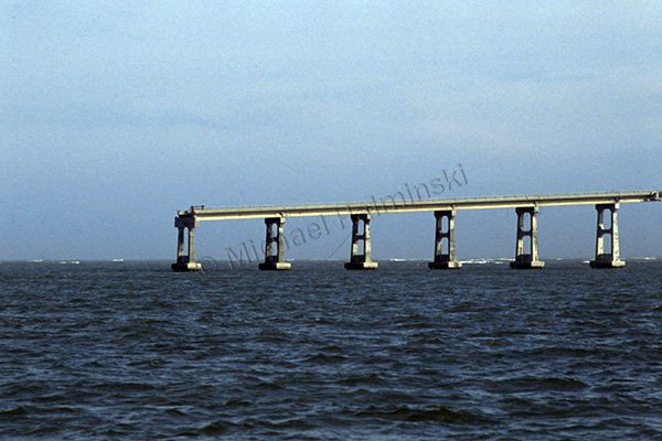
We hear a lot about Oregon Inlet, and the bridge spanning it. Nowadays you can hardly talk about one without mentioning the other. It’s nothing new and has been an issue for a long time.

When I first came here, driving over that beautifully curved bridge across the inlet was an awesome experience, the vistas remarkable. It was sort of an environmental work of art that served a purpose, getting to and from Hatteras Island. I would eventually learn that it was a bit more than that.

trawlers

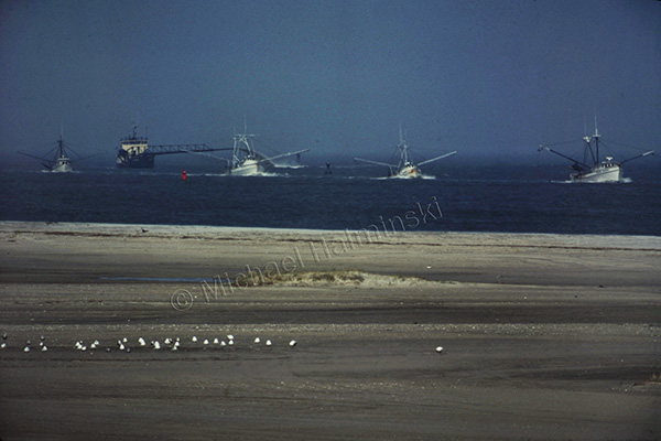
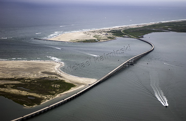
In April of 1977, while driving to Nags Head, I watched 4 trawlers coming in through the well-marked channel. There was no traffic and I had just gone over the peak of the bridge. I stopped overlooking Bodie Island spit, got out and took one shot with a 400mm lens on a fairly new Nikon F2.

aerial

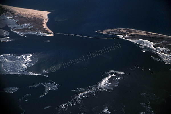
In January of 1985, we had a severe cold snap. Temperatures were low enough to freeze portions of the Pamlico Sound. I was so impressed that I hired a pilot to take me up and shoot the ice flows from above. We ascended to 7,000 feet, and the view was spectacular.

bailey boy

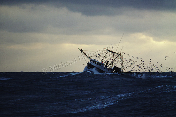
December of that same year, I was shooting a story on commercial fishing for Outer Banks Magazine. Arrangements were made for me to spend 3 days on a trawler from Wanchese, where Captain Terry Saunders welcomed me aboard the Richard Wayne”. There were 2 days of fair weather, but when a northeaster set in on the third day, the boats decided to come in early. Crossing the bar at the mouth of the inlet was rough, and Captain Stevie Daniels maneuvered “Bailey Boy”  through, right behind us.

station

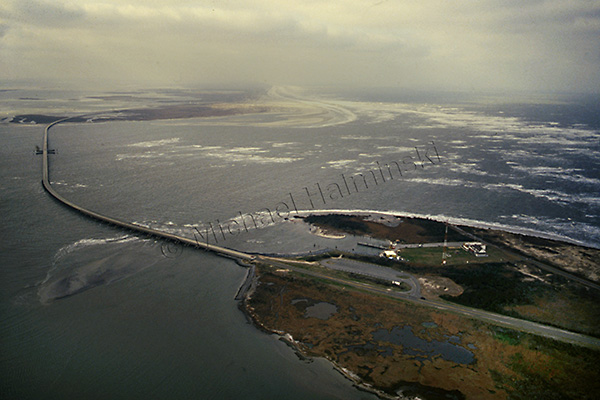
I flew during a northeaster in 1989 and made shots along Hatteras Island. There was no jetty in place at the inlet yet, and the Coast Guard Station was beginning to wash away. At the time, they were abandoning the station and moving to a newly built facility on the north side, next to the Oregon Inlet Fishing Center.

bridge

No recollections of Oregon Inlet would be complete without mentioning the October 1990 incident of a dredge taking out 400 feet of Bonner Bridge. I made this shot that December riding the ferry across the inlet when repairs were being made.

aerial '05

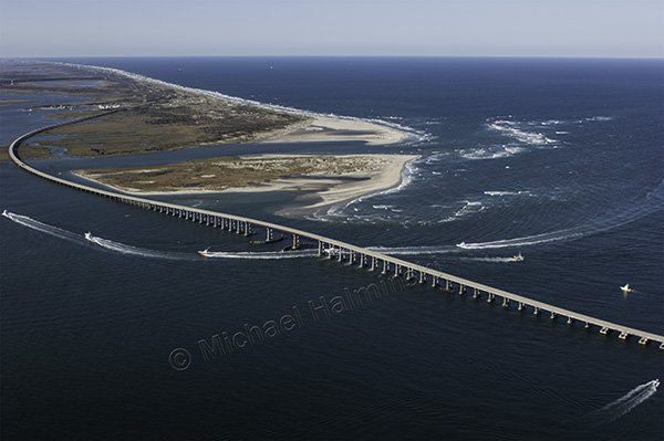
On an overcast September day in 2005, I went airborne with a videographer shooting a documentary on rising sea level. The section of the bridge that was taken out in 1990 is noticeable as a darker shade of gray in the pavement.

Irene

Hurricane Irene radically reshaped Oregon Inlet in 2011.

The only inlet on the east coast facing northeast, Oregon Inlet was originally formed in 1846. Since then, it has migrated over 2 miles south. Watching the area change and shift over the years continues to be fascinating. It’s a display of man’s engineering prowess in the face of some of nature’s most powerful forces. It’s also very expensive.


Skipjack and Cold Front

I’m often asked what my favorite picture is. The answer is that I can’t single out any one, from many preferred images.

One of my most endearing shots was taken the day before Thanksgiving, 31 years ago. I was into my second season of oyster dredging on the Chesapeake Bay, aboard the sailing skipjack, Virginia W.

There were reports that the day before another workboat, Hilda Willing, had dredged its limit of 150 bushels near the mouth of the Choptank River. With oyster populations in steady decline, that was a rare occurrence.

So early that Wednesday morning, all the Tilghman Island skipjacks set out for the same spot. There was no wind, however an approaching cold front was forecast to sweep in. We had our sails up ready to work. A light breeze began to fill in, though we were still underpowered and moving at a slow pace, barely able to pull a single dredge.

skipjack frontSkipjack and Cold Front-1982- prints available on request

As was typical of my working the middle deck, throwing the starboard dredge, I had my Nikonos rangefinder camera by my side. The massive clouds of the cold front began rolling in, getting closer. I looked over to see the Sigsbee, full sails up, waiting for wind. I took 6 shots, then put my camera away.

The front was an ominous sight as we prepared for more breeze. We tied 4 reefs in the main, deployed a second dredge and began catching a few oysters. Our speed increased, a gust of wind hit, and the boat heeled over, filling my right boot with sea water. There were some tongers  working nearby, and maneuvering was tight. Coming about for another lick, we had a near collision with one of them, our massive bow sprit crossing over his cabin top.

By that time it was blowing a gale, and impossible to control the boat safely. We dropped our sails, deciding to call it quits after bringing in 4 bushels and headed home for the Thanksgiving holiday.

Mirlo Madness

The road conditions at Mirlo Beach continue to plague NCDOT, as well as residents of Hatteras Island. It’s an issue that has been ongoing during the decades that I’ve lived here, and longer.

In the past several years the problem has accelerated and occurs more frequently. NCDOT’s reaction has been to perform the same repairs over and over again. They dig overwashed sand from the road surface, and pile it seaward to build a dune. Storms wash over the dune, moving the sand back onto the road.

The recent storm that moved off the coast buried the road and left standing water on the surface. I put my boots on and walked there to document the scene in photographs… again.

A number of homeowners in the Mirlo Beach subdivision have been trying to repair their condemned rental properties in hopes generating income. A pile of newly delivered lumber lies washed up in the sand. The approach taken to save Mirlo and highway 12 is not working.

The sign at Mirlo has become a contradiction.

NCDOT’s tools of preference for a fix is heavy equipment, but it’s no match against the power of the sea.

A front end loader is dwarfed in the environment.

An excavator removes sand from the road surface, and piles it on top of a huge sandbag barrier.

A bit of optimism is expressed in adversity.

Vehicles endure the salt water to access the island. During periods of high storm tides, the road is impassable.

The loosing battle continues.

A fixer upper stands tall in a setting sun.


Holiday Interlude

Christmas is unlike any other time of the year here. I’m often torn between traveling to see my family or staying home on Hatteras, to enjoy the solitude and nature of this wonderful place.

Holiday business was down and other than the dump trucks pummeling highway 12, there was little human activity. I got caught up on everything, sent out greeting cards and finished a small photography job.

With some time on my hands, I decided to stay on the island, relax and look for things to photograph.

One of the last times I used the 4×4 section of highway 12, I took a shot to record the moment.

With new pavement in place, workers were busy installing a barrier of sandbags, in hopes of protecting the highway. Seas have since washed over it, and sand is constantly being trucked in, to maintain a beach buffer.

Asphalt rubble from the old road was stockpiled, until it could be taken away.

To allow for construction, the S-Curve has been open to one lane traffic only. During the holidays, this was the view heading north.

The view looking south didn’t look any more promising.

As long as the road is passable, we can receive essential supplies.

The “corridor” just south of Oregon Inlet has also been an ongoing battle. Heavy equipment removes sand blown onto the road, only to have it blown right back. One could hardly find a better example of a vicious cycle.

It was predicted that the world was ending on December 21st. I celebrated by driving out to Cape Point during a gale. I was all alone to enjoy the place completely enveloped by nature.

Leaving my truck in the distance, I walked out to the point.

The wind and waves coming together, gave me a spectacular show.

Surfers were calling this “The Doomsday Swell”.

The most interesting spot was right on the point looking east. This is where two powerful forces meet. The south bound Labrador Current collides with the north bound Gulf Stream. Due to seas washing over the beach, I had to walk a quarter mile with a rising tide, to access the point.

One nice thing about coastal storms is experiencing the aftermath of clearing weather.

Rainbows are common yet elusive.

On January 5th, the Old Christmas celebration in Rodanthe marked the end of our holiday season. Larry Midgett joined me in bidding adieu to Old Buck, led by John Edgar.

As caretaker, John Edgar will put Old Buck out to pasture until next year.


Mirlo Beach Today

Two weeks ago I left Hatteras Island for a job in the Florida Keys. The road was washed out so Denise and I rode the ferry to Stumpy Point, a two hour transit to the mainland. It was blowing, and ferry service nearly shut down.

Goodbye Rodanthe!

View on the port side, with a Rodanthe bound ferry passing by.

Seas splash against the starboard side of the ferry.

Upon returning nine days later, we heard the 4×4 road was open, so we made our way south of Oregon Inlet, under police escort at 9 o’clock at night. With moderately brisk winds, the sea was rolling right up to our tire tracks, but we made it. I was amazed in the escalating deterioration of highway 12, compared to a few weeks earlier.

With another low pressure winding by today, I decided to have another look.

Mirlo’s broad side takes another beating.

A property owner’s defense seems fruitless.

The most photographed truck on the island lies abandoned.

The cottage on the right, Toes in the Sand, was the original house built on the oceanfront at Mirlo Beach in the late 80’s. Back then, it was called East Wind.

I just hope the electricity stays on.