Author Archives: j0jgvm89bj

Portsmouth Village Homecoming

For me, the most intriguing town on the Outer Banks is the village of Portsmouth. Situated on the northeast tip of Portsmouth Island, it played a significant role in local maritime history for well over one hundred years. It’s geographic location next to Ocracoke Inlet was important in making it a major port of commerce when wooden ships still sailed the seas. Deep draft ocean going vessels could offload goods there, and smaller boats would come from inland river towns to pick it up. From the 1750’s to the 1850’s, Portsmouth was a thriving seaport. According to an 1860 census, the town had a population of 685 residents.
But by then, things were beginning to change. A series of storms opened other inlets, and at the same time Ocracoke Inlet began to shoal. Shipping routes changed, commerce dropped off, and gradually the town dwindled to only a few people. With the death of Henry Pigott in 1971, the last man to live at Portsmouth, the last two residents, Elma Dixon and Marion Babb reluctantly left the island.

Today the 250 acre historic district of Portsmouth Village is a part of the Cape Lookout National Seashore. The remains of the town have been left intact and maintained.

Since 1992, the Friends of Portsmouth Island have sponsored a homecoming every 2 years. I went in 2008, and looked forward to this April 24, 2010 event. Again I was not disappointed. Here are a few things that caught my eye.

Descendants of village residents pose for a photographer in front of the Dixon/Salter house.

The Robert Wallace house.

The Dixon family cemetery.

The post office opens every other year for this event, including canceling postage stamps.

Ocracoke fisherman Gene Ballance demonstrates the art of net mending.

James Gaskill wears a device once used for fire-lighting waterfowl. He is also a commercial fisherman from Ocracoke.

At the old Coast Guard Station, Dave Frum explains the beach apparatus method for rescuing shipwreck survivors.

The Methodist Church was always a focal point of the community and still is.

88 year old Rudy Carter and Mil Hayes ring the bell to begin a church service. Rudy is a descendent of Henry Pigott, the last man to live at Portsmouth.

Get to the church on time if you want to get a seat.

Born in 1921, Dot Willis affectionally known as “Miss Dot”, is the last surviving resident that was born at Portsmouth Village. The light coming in the translucent windows of the church was very nice so I took the opportunity to speak with her, and make this available light portrait.

Back in the day, the flat-bottomed skiff was a preferred mode of transportation. These guys were fastening the bottom planks in a boat building demonstration.

Roy Willis from Stacy, NC was showing his waterfowl carvings.

Roy made and hunted over these green winged teal decoys last season.

The main tent provides seating for up to 500 people.

Then there’s the covered dish dinner with plenty for everyone. And the mosquitoes weren’t even that bad. If you go in 2012, I’ll see you there.

Group shot of attendees at the 2010 homecoming.


Buxton Woods Boat Works

In the early 70’s, there was a small migration of people that transplanted to Hatteras Island. They came because they enjoyed the island for what it was and what it provided. The surf, the fishing, the serenity were just some of the things to savor. The kicker was to somehow find a way to make a living. Some went into commercial fishing, restaurants, real estate or construction.

Mike Scott went into the boat building business. At his Buxton Woods Boat Works he made dories for the commercial fishermen to haul seine from the beach. He also did a lot of boat repair jobs. As he got busier, he hired Richard Ryder to help.  Richard was also a transplant, and like everyone else was looking for ways to make ends meet. He and Mike were not only good friends, but also excellent craftsman.

This 1977 photo shows a Mike Scott dory in use. Here Dennis Midgett on the left, and Pete Smith haul net in the stern to make another “set”.

With more repair jobs still coming in, Mike asked me if I wanted to help them out for a few months, so I began sometime in February of ’82. We restored two old shad boats that had been converted from sail to mechanical power. One of them belonged to Lee Peele, standing here on the right. It turned out to be a complete overhaul and it was a beautiful boat. Mike Scott stands proudly on the left.


This shad boat belonged to another Hatteras fisherman, Mark McCracken. We replaced some rotten planks and gave it an epoxy treatment.


Then Mike got two orders to build boats. One was a 24 foot, flat bottomed net skiff for a longhaul rig. The skiff took only a few weeks to finish, and was simple in design. For me, it was a perfect introduction to boatbuilding. It taught me a lot about “dressing” rough cut lumber, working with power tools and epoxy techniques. The lumber came from a small sawmill in Camden, operated by Mose White. Note the shad boat in the shop.


The other boat ordered was a 39 foot dead-rise, commercial fishing boat, designed after the Albatross II. Based in Hatteras Village, the Albatross Fleet has been around for years. They are tried and true, built in Marshallburg, NC.

Beautifully designed as very seaworthy displacement hulls, they are unlike the more modern, over the top, planing hulls. All the Albatross boats have rounded sterns, but this new one would have a square stern with rounded corners. It was made for “Big Bill” Foster, and would take over 6 months to construct.

The original Albatross was built in 1937.


The keel and bow stem are the backbone and were cut from yellow pine , then the heart cypress bottom frames were fastened to the keel… then the side frames installed.

The planks made from atlantic white cedar, are bent and fastened into place.


Richard Ryder applies epoxy to the finished hull.


Once outside the unpainted Mamacita is ready for a cabin.

Years later in 2007, Mamacita is still an active fishing boat.

Today Mike Scott is a boat captain and runs charters on the Albatross lll.

Richard Ryder went on to work for Hinckley Yachts in Maine, then began his own business called Union River Boat Company.

I left Buxton Woods Boat Works in September of 1982 to dredge oysters on the Chesapeake for the next 2 winters. See earlier post on Chesapeake Bay Skipjacks.


Jennette’s Pier

In 1990, I was privileged to be appointed to an advisory committee for the North Carolina Aquarium at Roanoke Island. I believe in the power of public education, and have remained with them ever since.

The North Carolina Aquariums are unique in that, North Carolina is the only state in the country to have 3 different and distinct facilities dispersed along the coast. Last week we hosted a joint advisory committee meeting, including advisors from Pine Knoll Shores and Fort Fisher. On a blustery Saturday morning, the group went to see the new Jennette’s Pier under construction. It is an amazing feat of engineering, and will be owned and operated by the North Carolina Aquariums.


For folks that love fishing piers or aquariums, it will provide a special one-of-a-kind experience, when finished. At 1000 feet long, it will have a 2-story pier house and alternative energy support. Ground breaking was in May of 2009 and completion is scheduled for May of 2011.

More information can be found at  https://www.ncaquariums.com/

A concrete piling rests on the south trestle, ready for installation.

This photo shows the pier house going up and piling arrangement from the work platform, or south trestle. 

This view of the pier construction from the 2nd floor of the pier house, shows the south trestle to the right. It is a temporary work platform, and will be removed.

This is the view from the pier house, facing west toward Sam & Omie’s Restaurant. Beyond is the bridge to Manteo.

Modern Day Shipwrecks

Often referred to as the Graveyard of the Atlantic, the ocean off the coast of the Outer Banks is  littered with hundreds, if not thousands of shipwrecks. Before modern modes of sailing, navigation and weather forecasting, commercial shipping was a more dangerous proposition than it is today.  Vessels transiting these waters however, still encounter problems.

I was reminded of this as I wrote a previous blog entry about the Sheila Rene running aground at Oregon Inlet. Similarly in October of 1977, as I was driving over the Bonner Bridge, south to Hatteras Island, I noticed a capsized trawler in the water next to the bridge. It was the fishing vessel Tosco. It was coming in the inlet with a 10,000 pound catch of flounder, when it ran aground and crashed into one of the bridge’s concrete piers. With a gaping hole in the hull, it sank right there on the spot. The boat was an estimated $100,000 loss, and the bounty of fish was also lost.

The Tosco at Oregon Inlet in 1977.

When most people think of shipwrecks along our shores, they think of the wooden sailing ships of the distant past. One of the last such wrecks was that of the GA Kohler. Built in Delaware in 1919, it was a 4-masted schooner, just over 200 feet long. Washing up in a 1933 storm, it is significant as marking the end of an era. It lay upright on the beach and was stripped in the war effort for materials, and subsequently burned. Some of the old artifacts, like wooden timbers, compass and even dinnerware, are in local homes today. The remains of the GA Kohler are currently buried beneath the beach sands near Ramp 27, but on rare occasions the remnants are uncovered by the ocean.

This photo from 1989 shows my friend Robin Gerald inspecting the stern section of the GA Kohler.

Since then, maritime mishaps have become less likely, and rare. Most of the activity on coastal waters nowadays pertains to sport or commercial fishing boats, and private yachts, among others. 

One exceptional event though, occurred in January of 1976 . It was during a freezing northeaster. I awoke in a bitter cold mobile home and couldn’t open the north door to get out. It had been frozen shut during an ice storm. The entire north side of the trailer was coated solid with 2 inches of ice. Once I got outside, I looked toward the beach and saw a sight that I could not believe. A 500 foot World War II liberty ship, Betelgeuse was washed up and towering on the beach. The moth-balled ship was being towed by a tug offshore when the storm hit with a vengeance. The tug, unable to handle the situation was forced to cut it loose. The ship sat on the beach for over a month until salvagers managed to move it, but not before Mac Midgett tied a line to it, claiming salvage rights. It was said that he made a few thousand bucks for his effort.

The World War II Liberty Ship washed in during an ice storm in 1976.

1987 was a banner year for stranded fishing boats. Here the Sweet Lady sits on the beach at Rodanthe, just yards from the pier. It was abandoned offshore during a storm as the crew evacuated via Coast Guard helicopter. It came short of hitting the pier, and was eventually salvaged.

The Hard 8 came ashore in “the hook” at Cape Point that same year.

When the Miss Manhattan washed ashore in 2000, it had hit the Rodanthe pier, and was dismasted in the process. It was salvaged.

The Sly Fox came ashore on Pea Island around Christmas of 2004… not so sly any more.

They say that one problem on the water, especially during severe weather, can turn into multiple problems very quickly. With distressed vessels in the Graveyard of the Atlantic this seems to be a common denominator.

Sound-side Flooding

The oceanside beaches and waves are what originally attracted me to Hatteras Island. But once I got established as a resident, I realized there was more to this barrier island. The Pamlico Sound, or bay side, is a unique and precious resource. I was really impressed by it’s bounty for the commercial fishermen navigating those waters. The Pamlico Sound, one of the largest estuaries in the country, is tranquil and beautiful. But I soon learned that it could also turn stormy and treacherous. It has claimed the lives of three of my personal friends, all commercial fishermen.

A cold front coming up the Pamlico Sound is a sure sign of changing weather.

Tides are generally driven by the gravitational pull of the moon. This is true, but the Pamlico Sound tides are mainly generated by wind. Winds blow the relatively shallow water from one side to the other. Here in the Rodanthe, Waves and Salvo township, winds from a westerly direction push the higher tides in our direction, while depleting the waters on the mainland side of the sound. Whenever we have a substantial west wind, we can get inundated by tides so high, that roads and properties get flooded. It’s times like this that a little elevation means everything.

In 1986, Charley went right up the middle of Pamlico Sound. Fortunately it was a minimal hurricane with winds of only about 80. The above image shows the commercial fishing harbor in Rodanthe with seas coming over the bulkhead and on to the roadway.

In 1999 a category 5 hurricane, named Floyd, made landfall in South Carolina. It wreaked havoc on the mainland to our west, but spared us with minor flooding and winds of only about 50 mph. Here I drive my old sacrificial Dodge truck through high tide near my home in Waves.

My yard during Floyd was under 2 feet of water. Here my neighbors, CE Midgett and Dale Midgett wade through the floating debris.

Conversely when winds wail from an easterly direction, the water on our sound side falls, sometimes enough to expose the bottom for a mile out, like during this northeaster in May of 2005.

The most severe tide that I’ve seen in over 36 years was during the March storm of 1993, when we experienced westerlies of 100 miles an hour. This was caused by a powerful low pressure system advancing up the east coast, not off shore, but centered to our west. We had tides driven 8 to 10 feet above normal. That day the sound waters met the ocean dunes. Cars were ruined and homes damaged by flood.  I had 4 feet of water in my yard, not to mention the breaking waves. Old timers say it was the worst flooding since the storm of 1944. Our worst case scenario is to have the eye of a powerful hurricane going right up the Pamlico Sound.

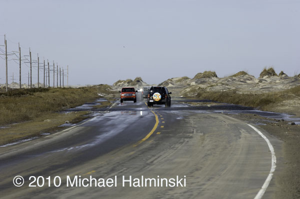
Just last week we had westerlies of 35 to 50, with higher gusts. The water came up quickly, although not with the ferocity that I’ve seen before. It was just enough to disrupt business as usual, and cause a nuisance. The tides were about 4 feet above normal. So I had several inches of tide in my yard. Portions of highway 12 were under 1 to 2 feet of salt water, not good for the life of transiting vehicles.

This last storm brought about 8 inches of sound tide in my yard. Home sweet home! The drill starts with vacating vehicles from the premises and parking them on higher ground.

My west property border meets the sound. As you can see, the vegetated wetland absorbs much of the wave action. I don’t understand it when people building on the Outer Banks clear cut, remove this buffer or fill the marsh. It’s really all that holds this sandbar island together.

This shot was taken last week, February 10. I wonder if this driver has a captain’s license.

Excessive tides have always been a way of life on Hatteras. It’s something that requires readiness and preparation. Sometimes it’s predictable. Other times it’s more of a surprise. It’s not a matter of if, but when the next one will occur.